Description
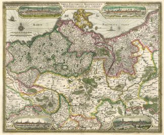
Tooley’s Dic. of Mapm. Rev. Ed. Q – Z, S. 331 (C.J. Visscher (1587-1652); Campbell, Claes Jansz. Visscher: A Hundred Maps Described – The Map Collectors’ Circle, Vol. V, 46, No. 18; Bott, 519. – Zeigt Brandenburg, Mecklenburg, Vorommern und Hinterpommern (Województwo Zachodniopomorskie). – In den 4 Ecken jeweils Gesamtansichten von Stettin (Szczecin), Rostock, Stralsund und Frankfurt (Oder).