Description
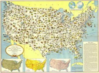
Dekorative USA Karte mit Einzeichnung der regionalen Bodenschätze, Produkte und lanschaftlichen Besonderheiten. – Am unteren Rand 3 Insetkarten mit den Haupt-Eisenbahnlinien, Haupt-Flugrouten und Gebiete sowie Haupt-Überlandstrassen. – Oben rechts westliche und östliche Hemisphäre mit Darstellung der relativen Größe und Lage der USA.Scarce government issued pictorial map of the United States, prepared by the US State Department Washington. – At the bottom of the map 3 inset maps: Principal trunk-line railroads, Principal air routes and terrain and Principal trunk-line highways. – At the top right, Inset of Western and Eastern hemispheres showing relative size and location of the U.S.A.