Description
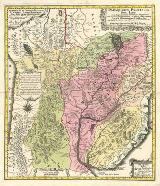
Sandler, Johann Baptista Homann, Die Homännischen Erben, Matthäus Seutter und Ihre Landkarten, S. 10, 196. – Seutter benutzte die Karte von D’Avilas als Vorlage. – Die Karte von Paraguay war die vollständigste und aktuellste Karte der vom Rio de la Plata trockengelegten Region und eine bedeutende Verbesserung gegenüber früheren Karten der Region. – Sie zeigt das Gebiet von Peru, dem Chucuito-See und der Quelle des Rio de La Plata bei Xareyes Lacas bis zur Mündung des Rio de la Plata, Buenos Ayres, Mendoza usw. – Die Karte zeigt den zentralen Teil Südamerikas vom Atlantik bis zum Pazifik, einschließlich des größten Teils von Peru, Bolivien, Paraguay, Brasilien, Uruguay, Argentinien und Chile, mit Flüssen und Nebenflüssen, Stämmen, Territorien und Siedlungen. – Die Karte mit Eintragungen der Jesuitenmissionsstationen. – Perfekter altkolorierter Zustand! – Seutter used the map of D’Avilas as a base. – The map of Paraguay was the most complete and up-to-date map of the region drained by the Rio de la Plata and a significant improvement over earlier maps of the region. – It shows the area from Peru, Lake Chucuito and the source of the Rio de La Plata at Xareyes Lacas to the mouth of the Rio de la Plata, Buenos Ayres, Mendoza, etc. – The map shows the central part of South America from the Atlantic to the Pacific, including most of Peru, Bolivia, Paraguay, Brazil, Uruguay, Argentina and Chile, with rivers and tributaries, tribes, territories and settlements. – The map with entries of the Jesuit mission stations. – Perfect oldcoloured condition!