Description
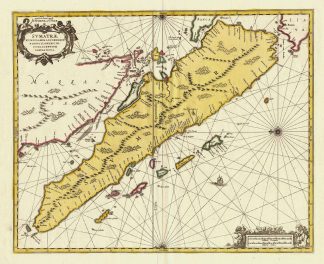
Koeman, Atlantes Neerlandici, Vol. II, S. 496, Me 169 B, (686); Tooley’s Dic. of Mapm. Rev. Ed. Q – Z, S. 307 (Gerard Valk / Valck, 1652-1726. Born in Amsterdam. Publisher, engraver artseller and globemaker of Amsterdam. … Around 1680 he began working with the German engraver Petrus Schenk, who later became his brother-in-law, as engravers, publishers, map and print sellers. …). – Zeigt die Insel Sumatra, sowie die südliche Spitze der Malakka-Halbinsel mit Singapur (Singapore). – Oben links Titelkartusche und Verlegeradresse. – Unten rechts Kartusche mit zwei verschiedenen Meilenzeigern.This map was one of the earliest detailed depictions of Sumatra and remained the most important map of the region until well into the eighteenth century. – The place name Senafur labels a promontory south of Ihor (Johor Baharu) in the vicinity of Singapore. – The map is further ornamented with two fine cartouches, compass rose and a sailing ship. – Excellent condition.