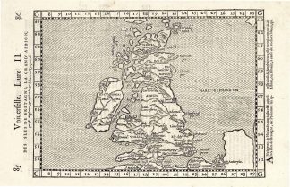
Beschreibung
Shirley, Early Printed Maps of the British Isles 1477-1650, 112. – Zeigt die Britischen Inseln mit England, Schottland und Irland.


650,00 € inkl. MwSt.
‚Des Isles De Bretagne, La Grand‘ Albion, qui est Angleterre, & Hirlande & de leurs citez en general.‘: Holzschnitt v. Francois de Belleforest n. Girolamo Ruscelli aus La Cosmographie Vniverselle De Tovt Le Monde. … b. Nicolas Chesneau & Michel Sonnius in Paris, 1575, 18 x 25 cm
Einzelstück
Shirley, Early Printed Maps of the British Isles 1477-1650, 112. – Zeigt die Britischen Inseln mit England, Schottland und Irland.