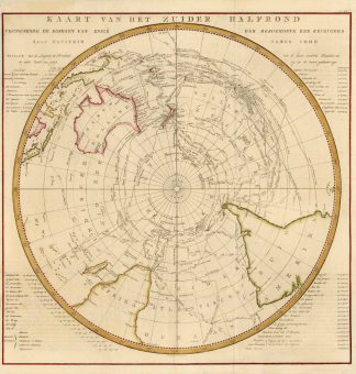
Beschreibung
Tooley’s Dic. of Mapm. Rev. Ed. A – D, S. 64 (Cornelis van Baarsel, 1761-1826. Dutch engraver for ‚Ollefen en Bakker‘. …). – Zeigt den Südpol (Antarktis) und das Südpolarmeer mit Australien und Neuseeland, das südliche Afrika und die Südspitze von Südamerika. – Die Karte mit Einzeichnung der verschiedenen Cook Reisen. – Am oberen Kartenrand dreizeiliger Kartentitel; in den vier Kartenecken geographische Erklärungen.Shows the South Pole (Antarctica) and the Southern Ocean with Australia and New Zealand, southern Africa and the southern tip of South America. – The map with drawing of the different Cook journeys. – Three-line map title at the upper edge of the map; geographical explanations in the four map corners.