Beschreibung
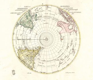
Phillips Atlases III, 3500. – Zeigt den Südpol (Antarktis) und das Südpolarmeer, das südliche Afrika, die Südspitze von Südamerika sowie Australien mit Indonesien. – Über der Karte Titelkopfleiste. – Unten links Stempel der Königlich preußischen Akademie der Wissenschaften. – Seltene Karte.Shows the South Pole with Southafrica, Southamerica, Australia with Indonesia. – The map is old coloured by a contemporary hand and has a stamp of the Royal Prussian Academy of Sciences. – Rare map.