Description
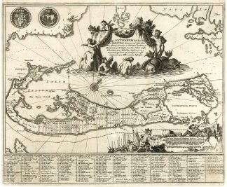
Palmer, The Printed Maps of Bermuda (in The Map Collectors’ Circle (No. 19), 12, plate VI. – The map was included in Montanus “Die Nieuwe en Onbekende Weereld: of Beschryving van America” and is based on Blaeu’s chart of 1635. – It shows the division into the original Tribes, or shares and shows the various landowners with their names in a table below the map. – Bermuda was colonized in 1612. – The map uses Blaeu’s previous projection to show Bermuda’s correct proportion and position in the North Atlantic by superimposing this map over a smaller scale map of the Atlantic with the coastlines of Britain, North America (Virginia) and Hispaniola, with a tiny island of Bermuda appearing just beneath the title cartouche. – The map with a decorative cartouche including Neptune riding a pair of sea monsters, surrounded by putti. – The scale of miles cartouche shows a vignette of natives and Englishmen surveying the land, and the coats-of-arms for England and Bermuda are displayed at top left.