Description
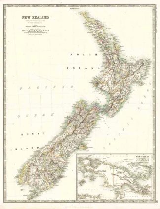
Tooley’s Dic. of Mapm. Rev. Ed. E – J., S. 447 f. (W. & A.K. Johnston, fl. 1826 – 1901. Founded by Sir William Johnston. Engraver and printer, later publisher of 6 Hill Square, Edinburgh <from 1825>; …). – Zeigt Neuseeland mit der Nord- und der Südinsel, die durch die Cook-Straße voneinander getrennt sind. – Oben links Titel. – Unten rechts Insetansichtkarte von Neuguinea mit der Aufteilung von 1884 wo die Niederlande die Westhälfte der Insel bekam, Großbritannien den Südosten (Britisch-Neuguinea) und Deutschland den Nordosten (Kaiser-Wilhelms-Land).