Description
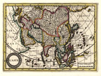
Bibliographisch nicht nachweisbar! – Diese sehr seltene Karte gehört zu einem nie beendetem Projekt der “Società Calcografia”, ein Zusammenschluß der beiden venezianischen Verleger des 18. Jahrhundert Antonio Zatta und Giuseppe Antonio Remondini. – Das Projekt ist nie beendet worden und die Karten in keiner uns bekannten Bibliographie aufgeführt. – Die Karte zeigt Asien zwischen Arabien und Bering See sowie Einzeichnungen der Routen der Schiffe “Felice” und der “Iphigneia (Efigenie)” nach Nordamerika im Jahre 1788 und nach China im Jahre 1788/89. – Unten links altkolorierte Titelkartusche. – Extrem seltener Einblattdruck! This very rare map belongs to a never finished project for the atlas of the so called Società Calcografia, a simple commercial trade realized by the two main Venetian publishers of the XVIII century, Antonio Zatta and Giuseppe Antonio Remondini. – The term Società Calcografica has been deduced from the map of the world, which is part of the collection and bears in the lower cartouche the French writing “à Venise Chez la Societè Chalcographique”. As already stated, the project was never finished for no atlas containing these maps has never been listed in any bibliography. Very likely, then, the maps have been sold individually, or maybe as part of smaller, custom collections. The maps of the collection derive from Paolo and Francesco Santini’s plates, used by Remondini in his 1782/4 “Atlas Universelle” and from the plates of Antonio Zatta’s “Nuovo Atlante” published in 1796. – Santini’s maps have been beautifully enriched, using the system of small, masked plates which can be perceived through the platemarks on the paper, with great cartouches according to the classical style of Zatta and have been probably engraved by the members of his staff, Pasquali, Zuliani and Pitteri. – The cartouches bear very often historical descriptions and maybe the maps have been realized to depict the great geographic changes of the peninsula during the Napoleonic period. – In our opinion, the two publishers worked together to the realization of the project until Antonio Zatta died (1804), and the complete atlas was never finished because Giuseppe Antonio Remondini also died in 1811.