Beschreibung
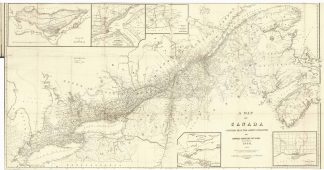
Tooley’s Dic. of Mapm. Rev. Ed. E – J., S. 447 f. (W. & A.K. Johnston, fl. 1826 – 1901. Founded by Sir William Johnston. Engraver and printer, later publisher of 6 Hill Square, Edinburgh <from 1825>; …). – Zeigt den Südosten von Kanada zwischen dem River St. Lawrence, Nova Scotia, Lake Erie und Lake Huron. – Ein wesentlicher Unterschied der Karte zu früheren Ausgaben besteht darin, dass neue Gemeinden sowohl in Ober- oder West- als auch in Unter- oder Ostkanada aufgeführt sind, einschließlich der Gemeinden im südlichen Bruce County. – Die Karte umgeben von 5 Insetkarten bzw. Insetpläenen („Island of Montreal“, Quebec and its Environs with the Operations of the Siege of 1759 under Wolfe“, „Vicinity of the Falls of Niagara“, „Kingston and its Environs“ und „Toronto and its Environs“. – Einige Faltstellen hinterlegt. – Die Karte im original Umschlag. – Selten!