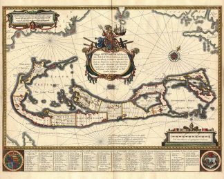
Description
Palmer, The Printed Maps of Bermuda (in The Map Collectors’ Circle (No. 19), 7, plate III; van der Krogt, Koeman’s Atlantes Neerlandici, Vol. II, S. 600, 9660:2. – Zeigt die Bermudainsel. – In der Kartenmitte Titelkartusche. – Oben links Kartusche mit Maßstab. – Unten rechts Kartusche mit Maßstab. – Am unteren Rand Wappen und Beschreibung.The map is embellished with a striking decorative cartouche, compass rose, and remarkable detail for the island, including a complete list of land owners.