Beschreibung
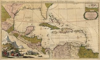
Tooley’s Dic. of Mapm. Rev. Ed. K – P, S. 285. – Zeigt den Kriegsschauplatz im Golf von Mexiko während des Spanischen Erbfolgekriegs. – Die Karte zeigt das Gebiet zwischen der Bermuda Insel, Florida, die Golfküste, Louisiana, Mittelamerika, nördliche Teil von Südamerika, die Karibik mit Kuba, Haiti, Dominikanische Rebuplik, Puerto Rico, Jamaika etc. und wurde während des Spanischen Erbfolgekriegs (Spanish Succession War 1701-1714) veröffentlicht. – Dieser Krieg fand auch als Parallelkriegsschauplatz in Amerika statt (Queen Anne’s War) – Der zweite der vier Franzosen- und Indianerkriege, in denen Frankreich und das Königreich Großbritannien in Nordamerika um die Kontrolle des Kontinents fochten. – Oben rechts Insetkarte der Insel St. Jean. – Unten links übergroße altkolorierte Darstellung einer Seeschlacht sowie Indigene mit Europäern und den Schätzen des Landes im Vordergrund. – Die Karte mit Einzeichnungen der Routen der spanischen Flotte zwischen Veracruz und Havanna, Cartagena und Havanna, Portobelo und Cartagena, Cartagena und Spanien und Havanna und Spanien. – Am linken Rand kleine restaurierte Fehlstelle. – Kupferstich von 2 Platten gedruckt. – Dekorative seltene Karte!Shows the war in the Gulf of Mexico during the War of the Spanish Succession. – The map shows the area between Bermuda Island, Florida, the Gulf Coast, Louisiana, Central America, northern part of South America, the Caribbean with Cuba, Haiti, Dominican Republic, Puerto Rico, Jamaica etc. and was published during the Spanish Succession War (1701-1714). – This war also took place as a parallel war in America (Queen Anne’s War) – The second of the four French and Indian Wars, in which France and the Kingdom of Great Britain fought for control of the continent in North America. – Top right inset map of the island of St. Jean. – Bottom left oversized old colored depiction of a naval battle and Indians with Europeans and the treasures of the land in the foreground. – The map with markings of the routes of the Spanish fleet between Veracruz and Havana, Cartagena and Havana, Portobelo and Cartagena, Cartagena and Spain and Havana and Spain. – Engraving printed from 2 plates. – Decorative rare map!