Beschreibung
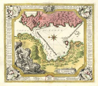
Fauser, Repertorium älterer Topographie. Druckgraphik von 1486 bis 1750, Bd. I, S. 362, Nr. 6515. – Zeigt die Befestigungen von Korfu mit Karte der Umgebung sowie die albanische und griechische Küste mit dem Kanal von Korfu anläßlich der Seeschlacht zwischen Venetianern und Türken im Jahre 1716.Shows the fortifications of Corfu with map of the surroundings as well as the Albanian and Greek coast with the canal of Corfu on the occasion of the naval battle between Venetians and Turks in 1716.