Beschreibung
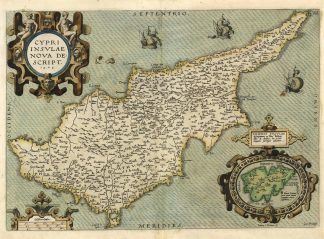
van den Broecke, Ortelius Atlas Maps (Second revised edition), plate Ort149 (3. state – only 150 copies printed); van der Krogt, Koeman’s Atlantes Neerlandici, Vol. III B, 8130:31B; Zacharakis, A Catalogue of printed Maps of Greece 1477-1800 (ed. 1992), S. 122, Nr. 1614U. Abb. S. 349, Pl. 337; Stylianou, The History of the Cartography of Cyprus, S. 60 ff., Nr. 66 u. Abb. S. 257. – Zeigt die Mittelmeerinsel Zypern; unten rechts barocke Kartusche mit Insetkarte der griechischen Ägäisinsel Limnos (Lemnos). – Rückseitig deutscher Text.